Remote sensing inventory for precision forestry
Reliable forest inventory information is a prerequisite for sustainable forest management. Day-to-day management and long-term decision-making include a variety of tasks such as planning harvests and silviculture, monitoring forest value and quantifying forest carbon impact. All related decisions suffer from poor inventory data, leading to less sustainable forestry in both economic and ecologic terms.
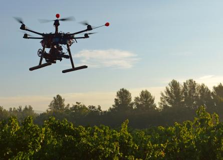
AFRY has developed a remote sensing toolbox for sustainable and precise forestry needs, making it possible to understand forest composition at individual tree and landscape levels. For vast areas with poor infrastructure, satellite remote sensing combined with field data and machine learning is a cost-effective choice for strategic-level analyses and investment decisions. For operational planning, individual tree inventories using drone images are now a realistic and efficient option.
Our remote sensing services
When selecting the right inventory system for your needs, take the following into account:
- Accuracy requirement, management unit size, expected users of the data
- Existing information, such as remote sensing data, old inventory data, models
- Available funding, equipment and infra
- Selecting either wall-to-wall measurement or stratified sample
- Processing of the collected remote sensing data into output variables
- Presentation and visualisation of the results, integration into forest management information systems
Our Smart Forestry team is available to discuss these questions and support deciding which inventory system fits your forestry organisation best.


- Hybrid inventory of individual trees and microstands
- Individual tree-level inventory for precision forestry
- Large-scale forest inventories with satellite remote sensing
- Carbon mapping and inventories
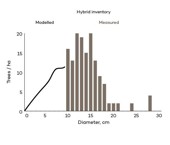
Hybrid inventory is applied when top accuracy is required, but the target area is too large to cover with drones. Typically hybrid inventory applies LiDAR data and aerial images captured by conventional aircraft survey. Input data can also be fused from many sources: drone or harvester data as training data to reduce manual field work and very high-resolution satellite data to replace aerial images.
Hybrid inventory approach makes it possible to extract, measure and interpret species of all mature trees. For younger forests, an area-based approach is applied.
The final result of hybrid inventory is a wall-to-wall forest inventory at tree, microstand, and stand levels. The hybrid inventory measures the diameter distribution of mature trees and models the smaller trees, providing an accurate breakdown of standing stock into timber assortments by species.
The right-side distribution chart illustrates how a hybrid inventory contains both measured and modelled data.

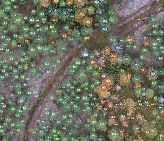
A tree-level drone-based inventory includes measurements of every single tree within a forest area, generating a database that can be used as input for carbon quantification, forest valuation or forest management planning.
Drone sensor configuration can consist of a camera sensor, LiDAR sensor, or both, depending on the user requirements for the inventory data.
Drones can map individual trees and measure their heights very accurately. Tree diameter and stem volume are estimated with tree-level models. Reviewing existing models and creating new ones is a standard component of the inventory system adoption process with AFRY.
Tree-level inventories are a building block of precision forestry, where optimising harvests and silviculture is taken to the next level.

Boreal forests
Boreal forests have long rotation times, varying silvicultural activity and multiple species within one management unit. With drones, we detect individual trees and species and aggregate the trees into management units. In the conditions of Nordic boreal forests, management unit-specific volume estimates can reach accuracies that are 50% better compared to traditional stand-by-stand inventories.
In addition to the production of traditional inventory attributes, the achieved accuracy improvement makes it possible to calculate tree-level CO2 sequestration and, thus, improve CO2 crediting precision.
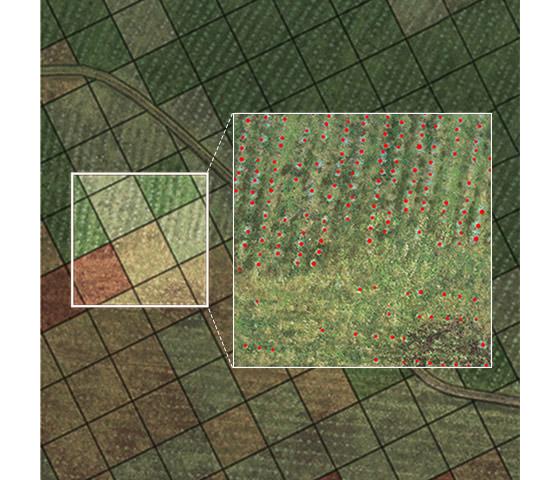
Plantations
Plantation forests in tropical countries grow fast and require intensive silviculture, making it essential to react quickly to changes in tree development.
AFRY's inventory service can be applied for tree-level survival mapping in young stands and for standing stock analysis in mature stands. Remote sensing-based survival mapping can be used to assign field personnel to investigate underperforming areas and conduct replanting or other silvicultural activities.
Drone or aircraft-based measurement of tree-level data fully covers stands' internal variation, thus enabling more accurate pre-harvesting inventory and better scheduling of harvests and silviculture operations.
AFRY has cost-effective and scalable methods to estimate the forest volume per species, species groups for forest stands or regular grids for vast areas covering hundreds of thousands or even tens of millions of hectares. Forest stands can be delineated if high-resolution EO data is applied, which ensures an accurate and objective description of productive forest areas.
Inventories of large forest areas can apply drone surveys and detailed individual tree-level inventories to reduce costly and labour-intensive field surveys. Drone-based surveys enable the cost-efficient collection of an extensive training sample combined with wall-to-wall satellite remote sensing datasets. AFRY’s machine learning workflows turn these datasets into inventory attributes covering even vast and remote areas.
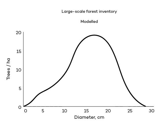
The right-side distribution chart illustrates how a satellite inventory only contains modelled data.

Carbon mapping projects can be implemented with existing data, as described on our Carbon mapping page.
AFRY can also carry out a thorough new inventory of the forest asset in case the existing inventory needs to be updated or more detailed.
For example, individual tree-wise inventory could be applied in voluntary carbon projects so carbon credits by individual trees could be presented and marketed.
-
Detailed and precise inventory data supports you in, for example:
-
Making better management decisions with more accurate inventory data
-
Effectively acquiring information about individual trees in the forest
-
Delineating forest management units from individually detected trees and upgrading the precision of harvest planning
-
Frequent and precise monitoring of your forests
-
Quantifying forest carbon storage at a high precision
-
Forest owners and managers
-
Forest industries
-
Voluntary carbon crediting organisations requiring forest inventory for precise baseline data and accurate calculation of additional carbon sequestration
-
Law enforcement authorities
AFRY Smart Forestry Products
AFRY Smart Forestry uses innovative software, state-of-the-art forestry technology and modern forestry techniques to improve forest management operations. Our products provide reliable information by mapping, optimising, monitoring and continuously learning about the forest supply chain's life cycle and functions.
We provide remote sensing inventory services using our own AFRY Smart Forestry Software.