Mapping the unknown
Creating digital twins of forests
Taking a stroll through the woods can be a relaxing experience that offers a peek into the forest’s current state, but there is much more to the bigger picture than the naked eye can see.
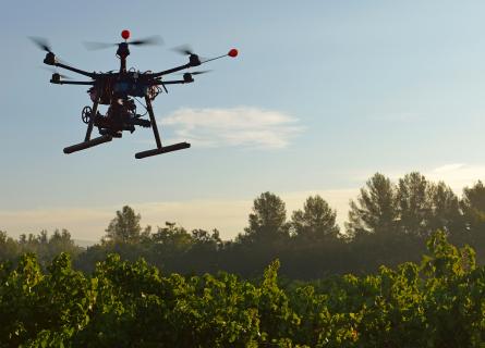
To understand the overall view, AFRY has developed its Smart Forestry product and service families, one of which is called AFRY Smart Forestry TreeMaps. Through high-flying remote sensing devices, TreeMaps recreates a digital twin of a forest area 1 so that the forest owner can maximise the benefits of their forest management efforts.

Forest inventories are traditionally implemented by manual fieldwork with very low sampling intensity, and inventory results are generalised from sample data to stand level. This method has been reliable in providing a general view of forest variables at a property level, but results are inaccurate at stand level due to stands’ internal variation. The estimation of species proportions has especially been inaccurate with traditional methods.
Remote sensing methods allow more precise and efficient automatic measurements since manual measurements can be reduced to the minimum. All inventory and monitoring needs of a forest area can be implemented with TreeMaps. Even carbon and the increasingly important structural diversity variables can be mapped accurately. For example, the amount of hardwood, deadwood and the tree species distribution of a forest can be defined.
The inventories provided by TreeMaps are inarguably the most cost-effective way to track forest structural diversity, which is important in maintaining forest biodiversity.
Precise forestry for precise needs
Forest owners, investors and companies that work in the forestry sector must have accurate data about their forests as the base for their decisions. For example, forest owners and wood purchasers need to estimate potential harvesting area volume, and investors need as precise information about forest value as possible for their proposals.
The need for accuracy can be answered by precision forestry, a term that has been used lightly throughout its history. Having invested considerable efforts in developing the offering from A to Z, we can put precision forestry into practice. Through individual tree mapping, our methods can determine the tree species, diameter, height and assortment distribution of any given forest.
Areas of various sizes require different measuring methods
TreeMaps has three alternative methods for creating forest inventories. Small-sized forest sites, rarely larger than 500 hectares, can be surveyed using drones flying 120 - 150 meters above the ground. The data gathered this way enables an individual tree detection method to locate and measure 100 % of trees in the forest area.
For larger forest areas, the main data source is LiDAR and aerial images captured by manned aircraft. Very high-resolution drone data is applied but now as a ground reference to decrease the need for manual fieldwork. We call this a hybrid inventory method.
Furthermore, satellite imagery can be utilised to gather forestry data from even more sizable areas that cover countries or continents. The method requires additional terrain support, i.e. detailed information provided by drones and aircraft or acquiring existing data about the site.

From the skies onto your screen
Typically, drone and aircraft surveys are carried out by the client or a third-party operator. After the survey flight, data can be processed by AFRY’s DaaS concept (Data as a Service), or the client can apply SaaS licensing to work independently. Each project starts with a preparatory phase to adjust processing details and required forest models to ensure the best results.
The platform unites TreeMaps with our other AFRY Smart Forestry solutions, Manager and Planner. These products help you manage your forest inventory and operations data and optimise your forest management activities.
Silviculture neither has a beginning nor an end
Understanding the current state of the forest through a forest inventory is important. However, detailed information about the state of the forest and the executed activities in the past are useful inputs for predicting the future. Forest Management Information Systems (FMIS) are globally used to store and manage this information.
FMISs usually include software like the aforementioned Manager, allowing forest owners to optimise their silvicultural operations. Our decision support system (DSS), Planner, introduces new functionalities such as comprehensive strategic and tactical optimisation models for setting long-term goals and executing short-term actions. At the same time, TreeMaps produces information for all systems mentioned above.
However, AFRY Smart Forestry toolbox has a feature that most systems worldwide lack: the possibility to create and utilise precision forestry-level information for better forest management.

Green values increase the worth of green gold
In addition to mapping economic values, environmental values are significant for more prominent clients. Carbon sequestration, i.e. how much carbon is absorbed in the trees and the soil of forests, has been a crucial indicator for a while in the collective efforts against mitigating climate change. More recently, biodiversity issues have risen beside it, and they even claim that “biodiversity is the next carbon".
Expedited by climate change, insect damage in forests is increasing as well. Bark beetles are especially problematic since they may infect entire spruce forests where trees need to be immediately cut to salvage part of their value.
The damage cannot be stopped or reversed, but financial losses can be minimised by targeted harvesting operations when pests are detected in the green-attack phase; multispectral and hyperspectral cameras can identify a narrow frequency of just a few nanometres that indicate changes invisible to the naked eye.
The future of remote sensing services
Up-to-date information about the actual condition of forest areas benefits both buyers and sellers. Creating an inventory of the forest estate ensures that any potential trade can be based on accurate and recent forestry data.
The ongoing development of TreeMaps focuses on scalability and production speed to further speed up the inventorying process. Imagine this: an interested person can drop by a forest owner’s place and discuss forest management and potential sales. They will send out a drone to scan and map the area, and the data will be analysed immediately, thanks to technological breakthroughs.
Smart Forestry
Our products bring reliability to your decisions by mapping, optimising, monitoring and continuously learning about the life cycle and functions in forest supply chains with the goal of improved forest management operations.
With sustainable forest management strategies and practices, we help you reach the objectives set for your forest assets - in a sustainable way.

Footnotes
- 1. Our methods are valid to cover any type of forest from any part of the world, but there are some practical limitations regarding precise inventories. a↩